
At about 9 am on August 26, a wall of water came down the river Bhote Koshi in Nepal’s Rasuwa district, destroying settlements near the border with Tibet, China, before pushing downstream into the Trishuli. Around 100 people were reported dead by the evening in Nepal, and about 400 were missing. It was, as per the country’s disaster management agencies, the second catastrophic flood to strike the same 30-km river stretch in 13 months. And the manner in which it happened forms a familiar pattern for a region that’s among the most seismically vulnerable in the world.
The Wednesday disaster, thus, was not an isolated accident of weather. It sat at the intersection of two processes that make Nepal one of the most hazard-exposed countries.
Advertisement – Scroll to continue
One, the warming of the Himalayas that leads to water being held in unstable places. Two, the mountain range is, in fact, still being built by two colliding tectonic plates.

A woman cries as she searches for relatives missing after flash floods in the Trishuli river in Nepal’s Nuwakot district on Wednesday, August 26, 2026. Photo: AP/PTI
Advertisement – Scroll to continue
What Appears To Have Happened
There are so far three accounts about what happened, and they largely tie into the same theory.
Nepal Foreign Minister Shishir Khanal told the House of Representatives that an earthquake at 8:37 am local time triggered a large landslide that blocked the river, and that the blockage then gave way. The US Geological Survey recorded a magnitude 4.4 earthquake at that time, about 47 km north of Gosainkunda, in neighbouring Tibet.
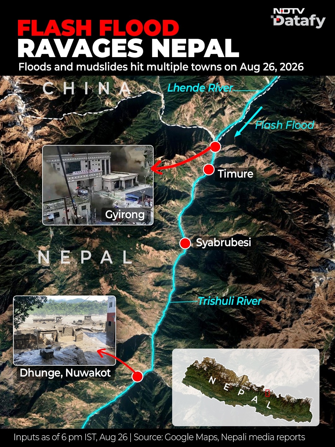
Some scientists offered a variant of this possibility. Saswata Sanyal of the International Centre for Integrated Mountain Development (ICIMOD) told CNN the worst flooding was on the Lhende Khola river, a tributary of the Bhote Koshi, and that an ice-and-rock avalanche from a glacier had blocked that river before water came out in a surge.
Rijan Bhakta Kayastha, a glaciologist and head of the Department of Environmental Science at Kathmandu University, gave a similar preliminary reading based on his discussions with scientists in Nepal and China, and noted that the Lhende Khola had been blocked in a similar incident the previous year. Satellite images from August 24 are also being examined for signs of water movement in the glacial zone upstream. A before-and-after assessment showed a sudden surge of water.
All three versions describe the same physical event, meaning that something plugged a Himalayan river, water piled up behind it, and then the plug failed.
One of the apocalyptic images came from the China-Nepal border crossing at Rasuwaghadi, where the bridge leading towards the central border gate was washed away, and dozens of people apparently died. This place is a familiar setting when disaster strikes this region.
This Has Happened Before, Many Times Over Centuries
Nepal is particularly vulnerable to such glacial lake bursts, also called “inland tsunamis”. Research by the regional institute ICIMOD noted recently that glaciers’ ice-loss rates have doubled across the Hindu Kush range of the Himalayas since the year 2000. That means heightened risk for the 2 million people who live downstream of these glaciers and the resultant rivers.
Not only was a similar flood last year traced to a glacial lakeburst in upstream Tibet, but even as far back as July 1981, a similar lake in the Zhangzangbo valley inside Tibet drained without warning. The World Bank’s review of such incidents later said the cause at the time was unknown, and became clear only years later through a Chinese scientific report. Research published in the journals Nature and Scientific Reports recorded that the 1981 event, which killed more than 200 people, destroyed the Friendship Bridge and severely affected the Sun Koshi hydropower station, came from the same lake system in Tibet. Major floods in 1964 and 1983 can also be traced to it.
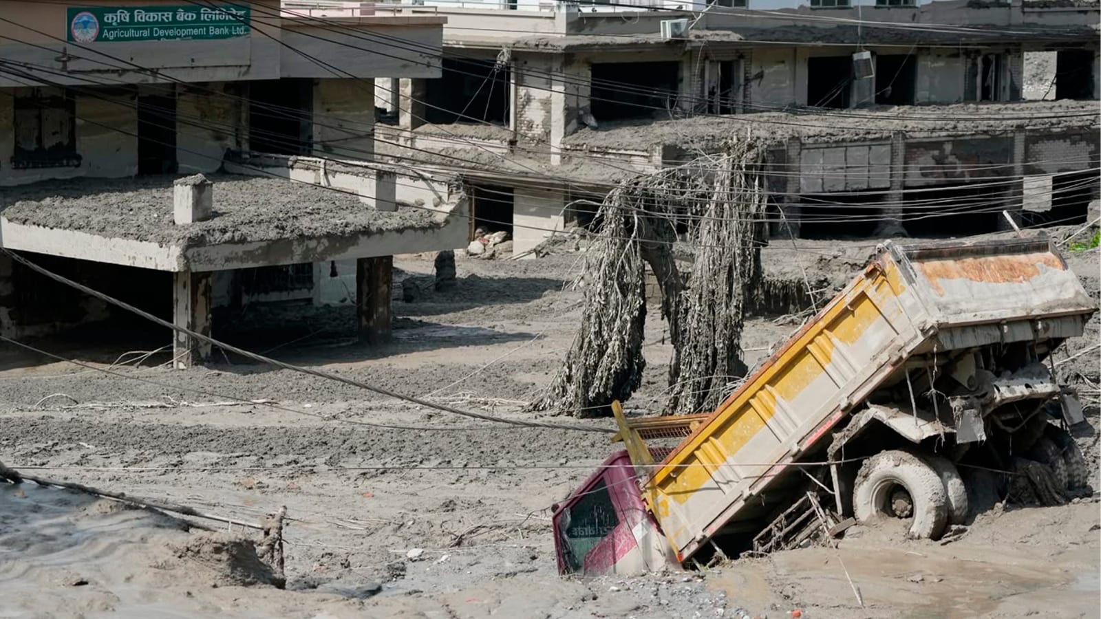
Downstream areas in Nepal hardly get any time to react when glaciers or lakes burst in Tibet, China. Photo: PTI
The record goes back centuries. The World Bank has counted 24 major outburst floods in Nepal’s past, 14 originating inside Nepal and 10 inside Tibet. These include one within Nepal 450 years ago in the Seti Khola river system, where a lake called Machhapuchchhre saw a moraine collapse, causing widespread damage in Pokhara valley, covering areas in 50-60 metres of debris. A moraine collapse is a technical term for when a natural ridge holding back a glacial lake gives way, causing an inland tsunami.
Last year’s flood at the same border point of Tibet/China with Nepal was traced more precisely. Washington-based Stimson Center’s analysis records that the July 8, 2025, flood was attributed to the sudden drainage of a supraglacial lake (ponds that form on the surface of a melting glacier) that had formed about 35 km upstream of the border at a height of roughly 5,150 metres.
Scale Of What’s Stored Upstream
There are hundreds of such lakes, as glacial ice melts and the water collects on the surface, precarious and dangerous.
An inventory by the UN Development Programme in 2020 listed 3,624 glacial lakes across the Koshi-Gandaki-Karnali basins. It identified 47 as potentially dangerous, 25 of them inside Tibet, 21 in Nepal, and one in India.
But such lists, too, cannot always help. Supraglacial lakes appear, grow, and drain over a few seasons, which means an inventory can be out of date before it is published. The 2025 disaster-causing lake, for instance, was previously unnoticed too.
Does China Warn Nepal?
A question that has followed every one of these floods is, why can’t Nepal find out earlier? After the July 2025 disaster, the director general of Nepal’s Department of Hydrology and Meteorology had said no mechanism existed for Nepal to obtain data from the Tibetan region. Warnings about rain do come from China, but GLOF (Glacial Lake Outburst Flood) events do not depend on rain.
For instance, Nepali officials said in 2025 they were informed about an hour before the flood entered Nepal, by border security personnel, not by any forecasting agency.
Nepal’s federal government decided after that flood to collaborate with China on early warning and preparedness. The UN Green Climate Fund approved a grant of around $36 million in July 2025 to help Nepal reduce the growing threat. But there is still no real-time alert system across the border, as the latest events showed.
A Permanent Problem: Mountains Still Moving
Beyond the glaciers melting, lakes forming and bursting, and no warning system, Nepal’s second vulnerability is more structural. Even permanent.
The country sits on the collision zone between the Indian and Eurasian plates, which converge 20-21 mm a year.
The Himalayas, in fact, began forming about 50 million years ago when these two plates collided head-on and closed the ancient Tethys Ocean. This caused the Earth’s crust to fold and thrust upwards violently, forming giant mountains, including its highest peaks. This is a continuous, slow-motion smash, still active, making the Himalayas the youngest and fastest-growing mountain range on Earth as they continue to rise by roughly 5 millimeters each year.
That generates immense strain, which is released in earthquakes.
For flood risk, even small quakes are enough. Every tremor shakes the slopes that may already be loosened by giant events, such as the 2015 earthquake.
On Wednesday, a magnitude 4.4 tremor, which most people would barely register, was reportedly enough to bring down a slope and stop a river, causing a sudden gush eventually.
Planet Labs को स्याटेलाइट तस्बिरको विश्लेषणका आधारमा गरिएको प्रारम्भिक अध्ययनबाट नेपाल-चीन रसुवागढी नाकाबाट करिब २० किलोमिटर उत्तरपूर्व नेपाल-चीन सिमानामा गएको हिम-चट्टान पहिरोका कारण ल्हेन्दे खोलामा गेग्य्रानसहितको बाढी आएको देखिएको छ। pic.twitter.com/kCAo9O1Zb0
— NDRRMA (@NDRRMA_Nepal) August 26, 2026
Nepal’s capital Kathmandu sits to the south of these mountainous border areas. Floodwaters and debris surged down river valleys towards areas like Bidur, about 50 km northwest of the city.
Debris Multiples As Construction Booms
The final factor is: where Nepal has chosen to build, and what. Construction on the China-Nepal trade corridors appears to have neglected the likely risk of outburst floods, with dry ports and customs offices being built along the river plains, research from 2024 showed. “GLOFs have cross-border effects, impacting (around) 103 km of China-Nepal highway, 103 bridges, two major dry ports and 3,301 buildings in both countries,” said research by, among others, Nitesh Khadka of the Institute of Mountain Hazards and Environment, Chinese Academy of Sciences, Chengdu.
The customs post at Timure, right at the Nepal-China/Tibet border near the Rasuwagadhi crossing, has already been destroyed twice in about 13 months. Scores of tourists, including Indian pilgrims for the Kailash Yatra, died in Wednesday’s disaster.
Plus, this is a region where electricity is generated. Nepal uses steep mountain rivers that flow rapidly through these narrow, deep valleys or gorges for hydropower plants. Which is why the Wednesday morning disaster cost the national grid 430 MW, over a tenth of the country’s capacity.
Downstream, GLOF surges feed the Trishuli, which becomes the Narayani at Devghat, and enters India as the Gandak. The consequences of an unmonitored lake in Tibet reach the plains of Bihar, destroying large parts of Nepal in the process.